Defining the Yamhill Valley
This is the Valley of the Vine
By JEB BLADINE
Publisher
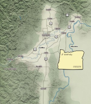
This newly created map has us saying, "There IS a Yamhill Valley, and we ARE in it."
The image of our valley takes the clear shape of a gently rolling "Y." It is surrounded by the Coast Range, Eola Hills, Dundee Hills and Chehalem Mountains, opening out near Newberg to the rest of the North Willamette Valley.
You won't find "Yamhill Valley" listed by the U.S. Board on Geographic Names, but you will find it in tales of Oregon history.
"In early 1856," according to The Oregon Encyclopedia, "the tribes that remained on the Table Rock and Umpqua reservations and in the Willamette Valley were later moved to the new temporary reservation in the Yamhill Valley."
An Oregon State Archives document titled "Provisional and Territorial Records Guide" provides this bit of history: "Whites first entered the area in 1814. Most were employees of the various fur companies operating in Oregon. Many of the American immigrants of 1843-1844 settled in the Yamhill Valley ... (which) ... quickly became the agricultural center of the Willamette Valley, producing high quality farm products."
Some people think we should be satisfied with simply being the northwest corner of Oregon's beautiful Willamette Valley. But we like the added identity of being the Yamhill Valley, known as the most celebrated core of Oregon's beautiful wine country.
We ARE in the Yamhill Valley, and we love it here. Welcome, and enjoy.


